
Most homeowners have a rough idea of where their land ends. They look at a fence, a flower bed, or a sidewalk and assume that is the boundary. The truth is that most of those markers were never verified by a licensed professional. They are educated guesses at best.
Knowing your actual property line matters whether you are planning a home improvement project, dealing with a question from a neighbor, or simply curious about what you own. This guide walks you through each step, starting with what you can check on your own and ending with when you need to bring in a licensed surveyor.
Step 1. Pull Your Deed
Your deed is the legal document that describes your property boundaries. It is the first place to look.
Most deeds describe boundaries in one of two ways. Newer properties use a lot and block number tied to a recorded subdivision plat. Older properties use a metes and bounds description, which gives directions and distances starting from a fixed point. A metes and bounds description might read: “Starting at the iron pin at the corner of Oak Street, go north 45 degrees east for 200 feet, then south 80 degrees east for 150 feet.” It continues until the full boundary is described.
You can get a copy of your deed through your county recorder or probate office. In most Alabama counties, it is also searchable online at no cost through the county property records portal.
Step 2. Find Your Plat Map
A plat map is a scaled drawing of your subdivision or lot. It shows the exact dimensions of your property and the location of your boundary corners. Think of it as the blueprint for your land.
Your county recorder or tax assessor keeps these on file. Many counties have made their plat maps available through online GIS portals where you can search by address or parcel number. The plat will show you the shape of your lot, its measurements, and where each corner pin should be located on the ground.
Once you have the plat in hand, you have a reference point. You know how wide your lot is, how deep it runs, and roughly where each corner sits. That is enough to begin looking for physical markers.
Step 3. Look for Iron Pins on the Ground
Property corners are marked with iron pins or rebar stakes placed by a licensed surveyor. These are your most direct evidence of where the boundary actually sits.
The pins are usually two to three feet long, made of steel or iron, and sometimes capped with a small colored plastic cap. They are typically buried just below the surface at each corner of your lot. You may find one near your front curb, along a shared fence line, or at the back corners of your yard.
To locate them, use the measurements on your plat map and start from a known point, such as the edge of your driveway or the front curb. Measure to where the pin should be and use a metal detector to sweep that area. The iron is detectable, and the pins are usually not set very deep.
Keep in mind that pins can be moved or buried over time by landscapers, utility crews, or previous owners. If a pin you find does not match your plat measurements, it may have been disturbed. Your actual property line does not change because a pin was moved. The legal boundary is defined by your deed and the original survey, not by where a stake happens to be sitting today.
Before you dig for a buried pin, call 811. This is the free national call-before-you-dig service that marks underground utility lines on your property at no charge. It takes a few minutes and can prevent a serious and costly mistake.
Step 4. Check Your County GIS Portal
Most Alabama counties publish parcel boundary data that you can view online by entering your address. These maps overlay your lot boundaries on a satellite image of your property, giving you a clear visual reference.
County GIS maps are more accurate than consumer tools like Google Maps, but they still carry a margin of error of several feet. They are useful for getting a general picture of your boundaries. They are not suitable for permit applications, legal disputes, or construction planning.
Use GIS as a cross-reference alongside your plat map and deed, not as a standalone answer.
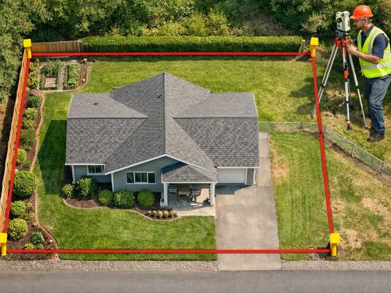
Step 5. Hire a Licensed Land Surveyor When It Counts
The four steps above help you understand and estimate your property line. A licensed land surveyor is the only person who can legally establish and certify exactly where it sits.
If your pins are missing and you cannot locate them through measurement and a metal detector, a surveyor can often replace a single corner stake for $200 to $400 using your existing survey records. That is less expensive than a full boundary survey and may be all you need.
You will need a licensed surveyor when:
- You are applying for a building or fence permit
- You cannot find your corner pins after a thorough search
- Your deed description and what you find on the ground do not match
- You are preparing to buy or sell the property
- A legal document requires certified boundary information
Which Method Fits Your Situation
| Your Situation | Best First Step |
| Just curious about your lot size | County GIS portal or plat map |
| Planning a garden bed or landscaping | Deed and plat map, then look for pins |
| Building permit required | Licensed land surveyor |
| Pins are missing | Metal detector using plat measurements |
| Buying or selling the property | Licensed land surveyor |
Frequently Asked Questions
How do I find my property line for free?
Start with your deed and plat map through your county recorder’s office, then use a metal detector to locate iron pins at your corners. County GIS portals also show approximate boundaries at no cost. These methods give you a solid starting point but do not carry legal weight.
What do property line markers look like?
They are iron or steel rebar stakes, two to three feet long, sometimes capped with colored plastic. A licensed surveyor places them at each corner of your lot. They are often buried just below the surface and can be found with a metal detector.
Can I use Google Maps to find my property line?
Google Maps shows approximate boundaries in some areas but can be off by several feet. Use it for a rough idea only. For anything that matters legally, such as a permit or a dispute, you need official records or a licensed surveyor.
When do I actually need to hire a surveyor?
When you are applying for a permit, involved in a boundary dispute, buying or selling land, or when your pins are missing and cannot be found using your plat map measurements.
How much does it cost to have a surveyor locate my property line?
Replacing a single missing corner pin costs $200 to $400 when an existing survey is available. A full boundary survey for a standard residential lot ranges from $500 to $1,500 depending on lot size, terrain, and the availability of prior records.